|
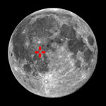
 Parry
est un cratère de 48 Km et profond de 560 m, attaché par le mur Nord-est à
Fra Mauro (95 Km) et au Sud-ouest au cratère Bonpland (60 Km). Au sud du
trio, on trouve le petit cratère de Tolansky (13 Km, 880 m). La muraille de
Parry est fortement érodée et légèrement tordu à cause des formations
Co-jointives. Le mur est le plus élevé au Nord-ouest. Le plancher a été
inondé par la lave donnant un aspect relativement plat tout en étant
constellé de craterlets. Au point médian on trouve les craterlets les plus
gros. Un rainure (Rimae Parry) longue de 300 Km passe par la partie Sud-est
de Parry.
Parry
est un cratère de 48 Km et profond de 560 m, attaché par le mur Nord-est à
Fra Mauro (95 Km) et au Sud-ouest au cratère Bonpland (60 Km). Au sud du
trio, on trouve le petit cratère de Tolansky (13 Km, 880 m). La muraille de
Parry est fortement érodée et légèrement tordu à cause des formations
Co-jointives. Le mur est le plus élevé au Nord-ouest. Le plancher a été
inondé par la lave donnant un aspect relativement plat tout en étant
constellé de craterlets. Au point médian on trouve les craterlets les plus
gros. Un rainure (Rimae Parry) longue de 300 Km passe par la partie Sud-est
de Parry.
 (English version,
Wikipedia copyright)
(English version,
Wikipedia copyright)
Parry
is a lunar crater that is attached to the southeast rim of the Fra Mauro
walled-plain. Attached to the west and southwest rim of Parry is the
Bonpland crater. Due south of Parry is the small Tolansky crater, and
further to the south-southwest is Guericke crater.
The rim of Parry is heavily worn and slightly distorted due to the co-joined
formations. The wall is the most prominent along the northwest, and crossed
along the southwest by the small 'Parry B' crater. The floor has been
flooded by lava, and is relatively flat. At the mid-point is a pair of tiny
craterlets. A rille system crosses the southeast rim in a northeast
direction before crossing the east rim and continuing a short distance
across the surrounding mare.
|